- A development environment with installations of the ArcGIS Enterprise SDK, NodeJS, and a JavaScript IDE to create the custom data provider package.
- A deployment of ArcGIS GIS Server with the custom data feeds runtime installed, which will host the published feature service.
- Further guidance on development and configuration for custom data feeds can be found in the documentation.
Data-level integration
Integration can also be accomplished at the level of data storage or persistence. This usually takes the form of data migration, extract, transfer, and load (ETL) and similar processes, which move data between systems. Some databases support connectivity to other sources (such as the foreign data wrapper in PostgreSQL, or linked databases in SQL Server), but generally data-level migration involves an automated, repeated data movement between systems. There are a wide variety of ETL tools that can accomplish this, including ArcGIS Data Pipelines and ArcGIS Data Interoperability, and most tools in this category can move data along with transforming or processing the data, such as changing values, enriching with geometric information, or changing format.
Data-level integrations should consider several topics carefully during the design phases of an architecture process:
- Update frequency - if data is integrated from another system of record, understand how often the other system is updating, and how long of a delay is expected or acceptable before updated data is visible in the ArcGIS system.
Recommended integration strategies
Some successful strategies that contribute to successful integrations during the architecture design phase include:
1. Take a strategic approach
Integrating enterprise systems changes the way an organization functions, providing new envelopes of time by reducing once expensive processes or tasks to repeatable, inexpensive activities. Leveraging enterprise integration in a priority strategic context can enable an organization to realize highly valuable outcomes by integrating processes, applications, or data to enable improved coordination in the production and delivery of a portfolio of products and services.
Apply this value proposition as a guidepost to defining initial requirements, develop scope and cost estimates, and make resources commitments for your integration effort.
2. Integrate at workload-appropriate and data-appropriate system tiers
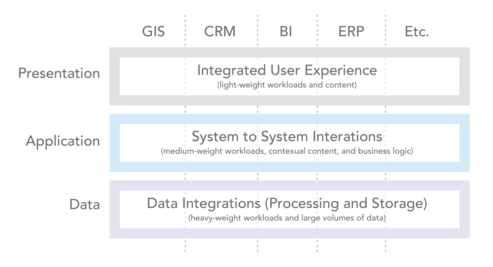
Enterprise integration is commonly achieved through orchestrating human and automated processes, including components embedded in the applications people use, providing access to the digital content or analytics produced by people and processes in other systems, or a combination of these approaches via application programming interfaces (APIs). It is also common to leverage shared systems and processes for enterprise identity and security within the technical landscape of enterprise integration.
3. Resource enterprise integration efforts effectively Enterprise integrations can be technically complex, often including multiple system tiers and detailed requirements for performance, security and availability. These projects often require software and systems engineering disciplines and experience that may reside outside of a traditional GIS team or project team. Allocating the right resources and team members from various parts of the organization is essential to ensuring that integration functionality performs as expected and allows users to focus on their work rather than the technology.
4. Ensure that data accessed across multiple systems is appropriate for use Integration between systems often brings data together that would not otherwise intersect, which introduces potential compilation concerns related to confidentiality, appropriateness and relevance. Information resources can be interpreted differently by enterprise or external users, so it is important for development teams to have a clear understanding of the meaning and scope of use for the various forms of digital content integrated between systems.
Misinterpretation of content types, fields, values, and so on, can lead to negative impacts that also degrade the value of enterprise integration investments. Strong data governance can contribute to this area by ensuring that developers and users understand the standards applied to datasets.
5. Implement appropriate network and information security Safeguarding sensitive information resources and systems is an important requirement for every organization. Network security ensures that appropriate personnel are authenticated and authorized to access and apply information resources. Information security measures ensure that the digital content resources are made available in an appropriate manner for every given audience.
Network and information security constraints for all forms of information may require multiple data processing stages to produce the right form of content that is appropriately suited to an intended purpose for a given audience. This can cause integration at data and application tiers to become complex and process automation is routinely required to transform or otherwise process data assets in motion from one system to another. Additional considerations related to security can be reviewed in the security architecture pillar.
6. Retire systems, data, and integrations that are no longer needed All enterprise systems should operate with a clearly-define life cycle. While evolution of these systems may be slow, change is inevitable and without clear life cycle planning many organizations struggle to govern their portfolio of systems, solutions, and integrations. Integrated enterprise solutions are dependent on the stability of the data and technology landscapes, and changes to these environments can interrupt the use of applications and associated workflows, impacting organizational productivity. As systems and their digital contents change, keep track of these dependencies so that enterprise integrations may be evolved, and when no longer needed, retired.
Conclusion
While many of these concepts are relevant to any enterprise information system, the integration of enterprise geographic information systems includes additional considerations such as geospatial data correlation and support for mapping visualizations and interfaces. Enterprise integration of ArcGIS systems with other business systems enables people across an organization to work together, with improved coordination, to apply geography more fluently and effectively.
In this topic
- Integration approaches and methods
- Integration approaches
- Integration interfaces or methods
- Application integration
- Service-level integration
- Data-level integration
- Recommended integration strategies
